River Wear
Woods, Riverside, Old Railway Line & The Victoria Viaduct
(Circular Walk - a tad less than 6½ miles. Mostly Easy - some moderate climbs. 3 hours - at a leisurely pace.)
Spelk's Printer Friendly Instructions
(Requires Adobe Reader)
1. The Victoria Viaduct
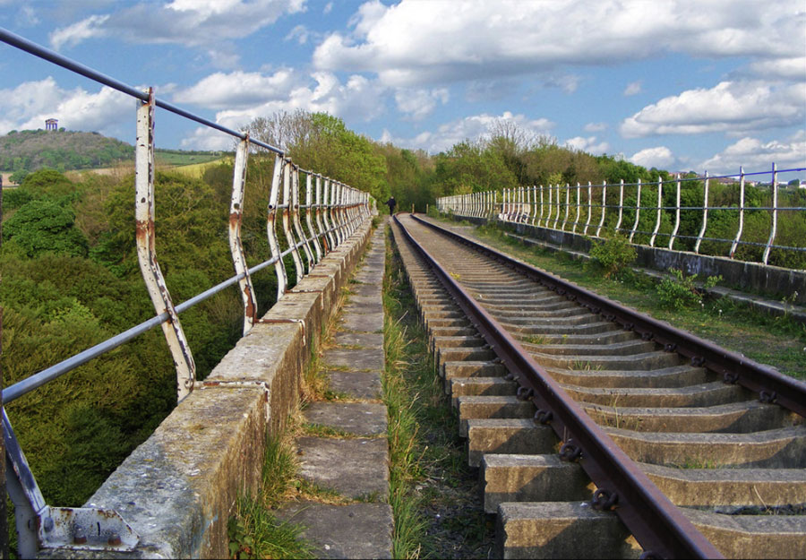
(Photograph by Lesley JB)
2. The Plan View
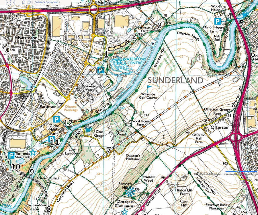
Reference: OS Explorer map 308 (Durham & Sunderland), NZ 330563.
(Courtesy of Ordnance Survey)
3. The Overhead View
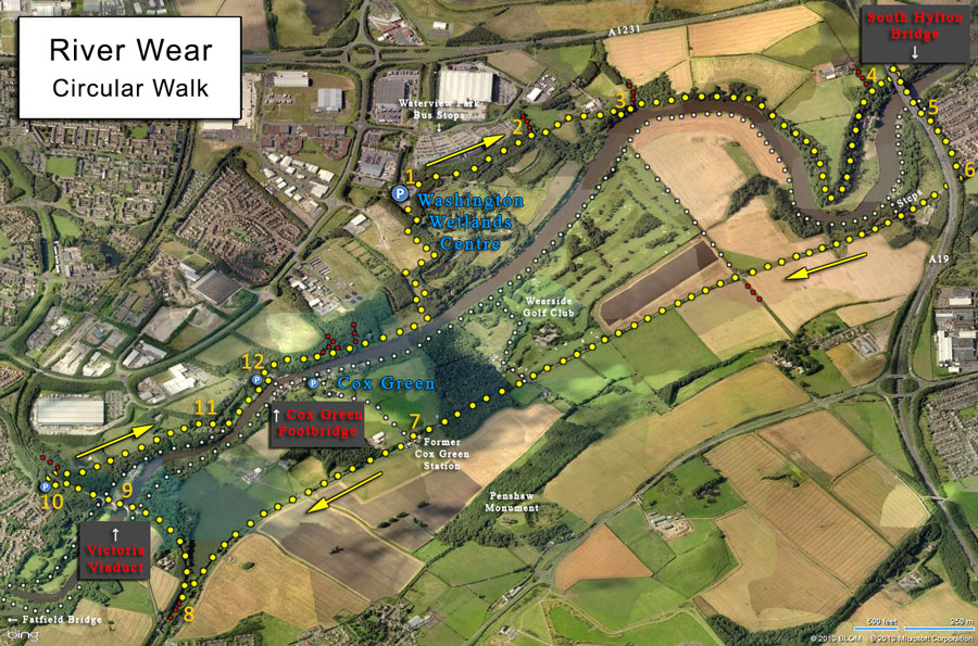
(Courtesy of Bing Maps)
The Route:
1. From the Washington Wetland Centre car park (or over-spill car park), take the footpath adjacent to the main entrance.
2. Do not turn left; follow the sign pointing to the South Hylton Bridge. After crossing a small bridge you'll pass a farm residence on your left.
3. The path drops steeply to the river at this point. Keep going, roughly parallel to the river, all the way to the South Hylton (A19) Bridge.
4. The old route turned left to a farm. It's now O.K. to continue under the box-girders of the bridge. Once on the other side, turn immediate left, climb the steps, and cross the bridge using the path on the Sunderland (east) side of the bridge. The view isn't bad, but this short section is very noisy and rather unpleasant!
5. Follow the path as it turns down to the left - do not continue alongside the busy A19. Walk uphill on the Yellow route to go along the old Penshaw to Sunderland branch line or, alternatively, take the White route downhill to go to Cox Green via the riverside.
6. Pass under the A19 dual carriageway via the underpass. There are several places along this railway line where you can take a White route to the riverside and walk upstream to the Cox Green footbridge. This will shorten your walk by 2 miles and avoid crossing the Victoria Viaduct.
7. This is the site of the old Cox Green railway station and it's your last chance to shorten the route by diverting to the Cox Green footbridge.
8. There are lots of trees where the branch line left the old Leamside Line, so keep a sharp look out to your right for a stone-ballast former railway line (without rails or sleepers) curving north towards the Victoria Viaduct.
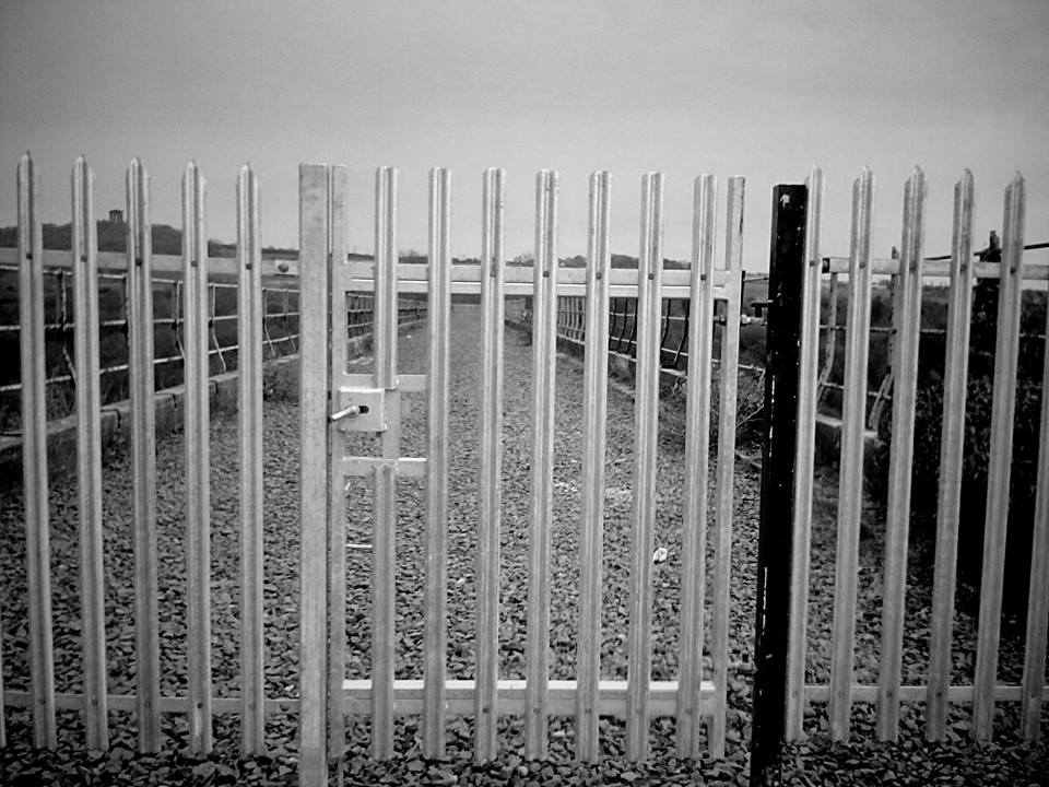
9. The magnificent Victoria Viaduct. Admire the views but keep well back from the inadequate metal fencing - see above photograph.
10. After crossing the Viaduct, continue until you see a dirt track, on your left-hand-side, leading down to a small car park. Leave the car park through a tunnel under the railway line and enter the James Steel Park. Take the path to your right and continue parallel to the river.
11. When you leave the park, walk to the grassed area adjacent to the riverside and then downstream towards the Cox Green footbridge.
12. There's a house very close to the north end of the footbridge; take the short steep track running along its north side. Continue parallel to the river until you reach the point where the path turns 90 degrees to the left. Follow this path uphill keeping the Wetland Centre fence on your right-hand-side. You'll soon reach the car park
Comments:
1. The Wetlands Centre car park and overspill area are free but I'm not sure whether that's subject to buying a ticket. Nobody bothered us!
2. I'm not sure about the legality of crossing the Victoria Viaduct. Lots of people include it in their walks. Do take care!
3. The large government office block at Waterview Park is served by several buses. It's only a 2 or 3 minute walk to my chosen starting point.
4. With 3 main routes between the Cox Green and South Hylton Bridges (Woods, Riverside & Old Railway track) plus the option of walking clockwise or anti-clockwise, you have a choice of 6 return journeys on the main section of the walk.
You could while away many a day on this section of the River Wear. I love it!
5. Walked on Thursday 20th June 2013.
Bad News Update:
April 2014